


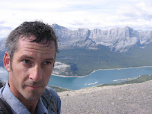
Suz and I made a questy ascent of Ha Ling peak this weekend. A mostly steep and tedius climb up to 7,900ft. The reward was worth it as the final summit push follows the edge of a razor with several thousand feet on each side. Had a bit of vertigo for myself though Suz found a way to lean backwards over the precipice to photograph her head suspended over the bow valley thousands of feet down.
5 comments:
i thought it was called "ho ling," or the less p.c. "chinaman's peak," and i never actually made it to the top. rather, i tried a shortcut and ended up crabwalking down a loose-gravel mountain face, crying most of the way. nice work, though!
Aargh! No google map link. Okay here it is
click click click.
And elevation in feet?
2.407 km for Dave's Canadian readership.
And where is the crazy upside down pic you tease us with?
Certainly not a trip for a quester with a less than perfect shoulder. I trust all is well in that dept?
I was wondering what you have been up to lately. Hope you drop in to have coffee in S'toon before the snows cover the pass.
I still have a few holdover imperial units. Still can't fathom heights or elevations in metric. The upside-down picture is on suzanne's camera perhaps coming soon. Shoulder is doing pretty good, just the sub-scapulus is grieving me yet but certainly my range of activity is increasing.
Oh, hey, we here in the City of 7 Sins need the 60 Second Brand Strategist to complete out Quest readings.
Post a Comment